

← Browse Harford · Browse Tors & Landmarks · Browse the directory
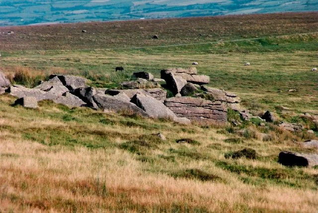
Main image: Sharp Tor on Harford Moor, September 1997. Photo: Barry (CC BY-SA 2.0) via Wikimedia Commons
- Parish: Harford
- Height: 414 m
- Grid reference: SX 6489 6172
- Rock: Granite (an emergent tor)
Sharp Tor on Harford Moor lies on a spur above the valley of the River Erme, about 6 km north of Ivybridge, south-south-west of the cairn that stands nearer the Redlake Tramway. Most people come to it from the east, which is the side that hides it: the tor only shows its best side once you climb the low outcrop on the spur and look on to the main rocks.
The name comes from the rock face, which steepens abruptly. Below it the ground drops almost vertically to a wall and Piles Copse, one of Dartmoor's three ancient oak woods, with Wistman's Wood and Black-a-Tor Copse. The rock face pushes out into the valley as a ridge that would shelter you from an easterly wind.
The views run up the Erme valley to its source, across the valley to Hillson's House on Stall Moor, and on a clear day over Plymouth and the South Hams coast as far west as Torpoint in Cornwall. A pipeline contours the hillside: it was built to carry china clay down from Redlake and was later abandoned. A larger but ruined outcrop at SX 6500 6165, with striking horizontal joints, can be reached along the Redlake tramway track, which has hardly any gradient.
Dartmoor has several tors with this name. Not to be confused with the Sharp Tors at Lydford, Tavy Cleave, Chinkwell, Yartor Down, Peter Tavy and Castle Drogo, nor with the two Sharpitors, Sharpitor near Burrator and Sharpitor at Lustleigh.
This is a location on Dartmoor that has a namesake. Read more about this: Dartmoor Places With the Same Name
Explore further
Contact us if you have information about this listing
Official record
Explore the area
Go deeper with Dartefacts
Dartefacts is a database of Dartmoor sites with far more close-up detail than we can show here, and it is the best place to go deeper. Dartefacts is free to use, and nobody has to pay to look things up. If you want more, a yearly subscription adds 10-figure grid references, map zoom down to 1:25,000 and lists to tick off the places you have visited, and it helps keep the site going. We would encourage you to subscribe.
Thoughts
Be the first to share a thought about Sharp Tor, Harford Moor.
Share a thought Photograph by Glavind Strachan Photography
“God bless 'ee, ma'am. I be 'most too dry to breathe." ... "Reckon you seed me in the bogs just now, trying to find a drop of water?" ... "Not today. The little spring, her'd been getting drier every day, and this morning I found her'd a gone altogether. Tomorrow I must bring more tay.”
Also on Our DartmoorHut circles — Bronze Age hut circles and field boundaries east of Mel Tor, a scheduled monument on central Dartmoor.
Know another Dartmoor place, tor or landmark we should include? Suggest a listing, it is free.
Suggest a listing