

← Browse Prehistoric Settlements · Browse the directory
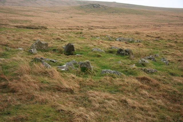
Hut circle settlements west and south-west of Devil's Bridge
Princetown, Yelverton, Devon
Grid ref: SX 5762 7274
Main image: Photo: Guy Wareham (CC BY-SA 2.0) via Wikimedia Commons. Hut circles on Walkhampton Common beside the B3212, at the south-west enclosed settlement.
- Period: Bronze Age
- Status: Three scheduled monuments (Historic England entries listed below)
- Huts: 14 hut circles in these three entries
- Where: Walkhampton Common, 380 m to 900 m south-west and west of Devil's Bridge
Two small settlements lie close together on a gentle south-facing slope above the Meavy valley, 380 m to 400 m south-west of the bridge. The larger is an irregular enclosure 70 m east to west by 32 m north to south, with six hut circles joined to its boundary. The boundary is a lynchet, a bank formed by ploughing, up to 2.5 m wide and 0.4 m high. The huts are 4.2 m to 9.5 m across inside (6.6 m on average), two have two rooms and two have a doorway you can still see. A field wall 65 m long runs south from the enclosure, part of a field system that is mostly buried. Historic England notes that the deep peat here has protected what lies underneath. Just south of it is a single hut circle, 6.6 m across inside, an outlier of the same settlement.
A third settlement, 900 m west of the bridge above Yes Tor Brook, has at least seven huts on a south-west-facing slope. Every hut has a clear doorway, which Historic England calls unusual. They are small, 7 to 19.6 square metres inside (about 10 on average). Two pits in the monument, 0.7 m and 0.8 m deep, were probably dug in old prospecting on Walkhampton Common.
The larger unenclosed settlement of 36 huts lies north-east of these, between the bridge and Hart Tor: see Hut circles between Hart Tor and Devil's Bridge.
The three scheduled monuments
| Historic England entry | Grid reference | What survives |
|---|---|---|
| 1011253 | SX 57823 72668 | An irregular enclosure 70 m by 32 m with six hut circles joined to its lynchet boundary; two huts have two rooms. |
| 1011254 | SX 57856 72603 | A single hut circle 6.6 m across inside, in a bank 1 m wide and up to 0.4 m high, an outlier of the enclosed settlement to its north. |
| 1018931 | SX 57201 72970 | At least seven huts above Yes Tor Brook, every one with a visible doorway, and two small prospecting pits. |
Grid references are from the Historic England entries. Each entry covers one scheduled monument; a monument can hold several features.
Contact us if you have information about this listing
The 3 rings on this map are the separate scheduled monuments that make up this listing, placed from Historic England’s records. Tap a ring for its grid reference and a link to its official entry. The pin marks the middle of the group.
Official record
Explore the area
Go deeper with Dartefacts
Dartefacts is a database of Dartmoor sites with far more close-up detail than we can show here, and it is the best place to go deeper. Dartefacts is free to use, and nobody has to pay to look things up. If you want more, a yearly subscription adds 10-figure grid references, map zoom down to 1:25,000 and lists to tick off the places you have visited, and it helps keep the site going. We would encourage you to subscribe.
Thoughts
Be the first to share a thought about Hut circle settlements west and south-west of Devil's Bridge.
Share a thoughtKnow another Dartmoor place, tor or landmark we should include? Suggest a listing, it is free.
Suggest a listing