

← Browse Other Heritage Sites · Browse the directory
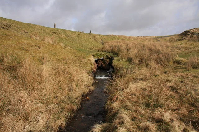
Main image: Photo: Guy Wareham (CC BY-SA 2.0) via Wikimedia Commons. The culvert at Devil's Bridge, which carries the B3212 over the Meavy.
- Where: the B3212 over the River Meavy, just over a kilometre south-west of Princetown, SX 58050 72880
- What: a small stone culvert carrying the road over the young Meavy
- Status: not listed or scheduled as a bridge; Bronze Age monuments around it are scheduled
Devil's Bridge carries the B3212 over the River Meavy a short way below its source. It is hardly recognisable as a bridge now: the stream runs in a narrow channel to a small stone culvert under the road embankment. The name is said to have come from workmen in the area, probably because of the severe S-bend the road once took here. The bend was straightened in the 1960s, and a map of 1906 shows the old route. No date for the bridge or builder has been found.
The ground either side is a well-recorded Bronze Age settlement landscape on Walkhampton Common. A large unenclosed settlement of 36 hut circles lies between the bridge and Hart Tor, and in 1895 the Dartmoor Exploration Committee dug 18 of the huts: Hut circles between Hart Tor and Devil's Bridge. Two smaller settlements 380 m to 400 m south-west of the bridge and one 900 m west are on the page Hut circle settlements west and south-west of Devil's Bridge, and a Bronze Age ring cairn lies 220 m south-south-east: Ring cairn near Devil's Bridge.
The same slopes were used by the army: three granite distance markers from a 19th century rifle range stand inside the scheduled settlement. About a kilometre south, the valley holds the remains of tin working, described on Tinworks at Stanlake, Black Tor, Hart Tor and Cramber Tor.
Suggest an edit to this listing
Contact us if you have information about this listing
Official record
Explore the area
Go deeper with Dartefacts
Dartefacts is a database of Dartmoor sites with far more close-up detail than we can show here, and it is the best place to go deeper. Dartefacts is free to use, and nobody has to pay to look things up. If you want more, a yearly subscription adds 10-figure grid references, map zoom down to 1:25,000 and lists to tick off the places you have visited, and it helps keep the site going. We would encourage you to subscribe.
Thoughts
Be the first to share a thought about Devil's Bridge.
Share a thought Photograph by Glavind Strachan Photography
“One day two parsons started forth To walk to Cranmere Pool, The weather was not really hot, Nor was it very cool. They walked and talked for hours and hours As only parsons can, Until it seemed as though they'd trudged From Beersheba to Dan. At last they reached the pool and Lo! With ...”
Also on Our DartmoorA Hundred Years on Dartmoor — Historical notices of Dartmoor Forest during the nineteenth century, first collected into book form in 1901 from a newspaper series; the free scan available online is the 1902 fifth edition.
Know another Dartmoor place, tor or landmark we should include? Suggest a listing, it is free.
Suggest a listing