Besley's map of Dartmoor is a folding sheet map printed in Exeter by H. Besley & Son in the 1870s, I won it in a local auction and thought I'd share it with you. Here you are able to zoom into a high-resolution scan of it, search more than 900 old Dartmoor place names, and compare the Victorian spellings with the names we use today.
Explore Besley's 1875 map of Dartmoor
Feel free to explore this great old map - drag to move around, scroll or pinch (on mobiles) to zoom. You can also type a name into the search box to jump to where that location appears on the map. A red box shows you the spot. On a phone, the full-screen button below gives you more room.
I scanned the map at 600 dpi (I don't have a great scanner) in eight pieces and they were stitched together by an AI agent (it's done a fairly good job, but if anybody wants a certain section scanned again for any reason, let me know). The names you can search were read off the map both by AI and by eye and then put into a searchable database and cross referenced with my own slowly increasing "Dartmoor Library".
It's likely a few will probably have been misread. If you spot one, let me know.
I don't think this map has finished telling me things. Every time I look at it closely something else turns up: a name that is not where it should be, a spelling I've not seen before, a farm that has vanished.
Please explore it, and if you spot something odd, or know the answer to something I have left hanging, get in touch. I am scanning more old maps and books of my own too, and I expect to find plenty more rabbit holes to dive down. Some of them will end up as articles here.
The map at a glance
- Title: DARTMOOR. (with a full stop - Important to identify the year - we're guessing about 1875)
- Maker: H. Besley & Son, Directory Office, South Street, Exeter
- Date: not printed. Late 1874 to about 1883 from the railways drawn on it - 1875 is an educated guess!
- Size: 520 x 395 mm, folded into plain green boards
- Names read off it: more than 900 place names
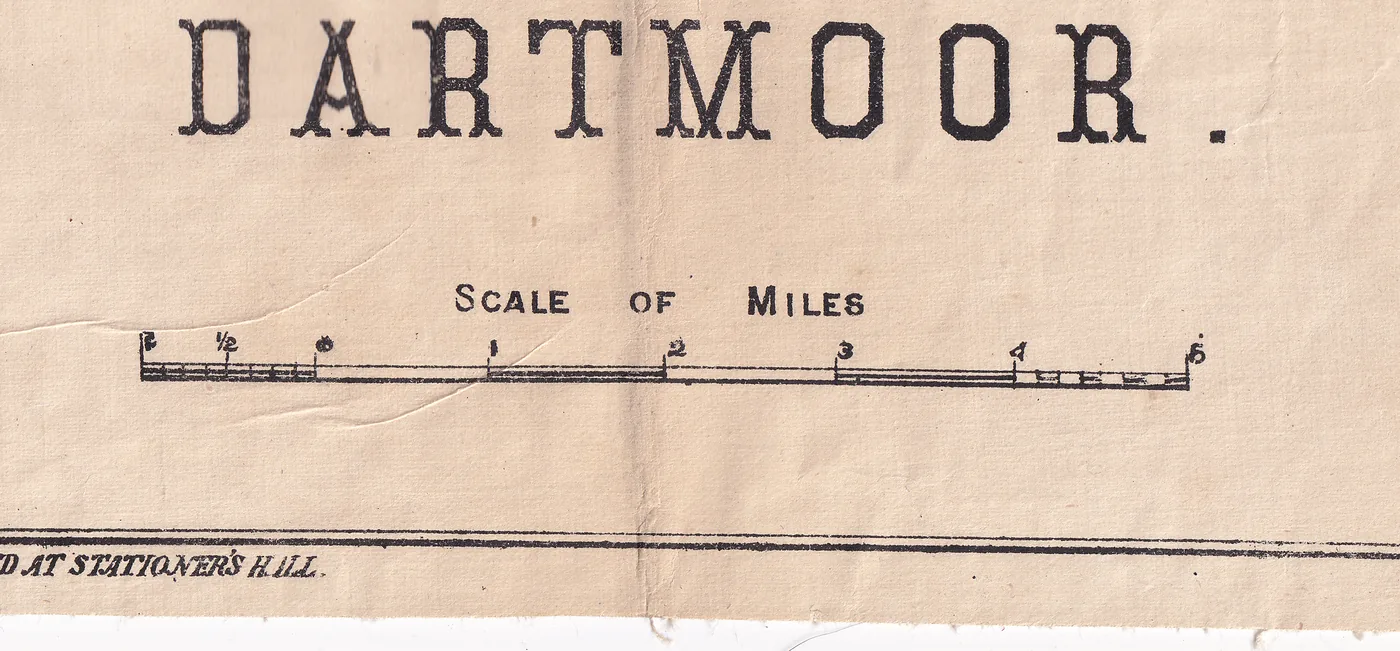
Who made Besley's map of Dartmoor?
Henry Besley (1800 to 1886) took over an Exeter printing business in 1834. By about 1872 it was Henry Besley and Son, "Directory and Time Table Office", based in South Street. They printed Exeter directories, a Route Book of Devon with county maps, and sheet maps like this one. Later the firm became Besley & Dalgleish and then Besley & Copp; the Copp premises were apparently bombed in 1942.

When was Besley's map of Dartmoor made?
The map has no date, so the answer is guess, not a definite. The railway from Yeoford through Okehampton to Lydford opened on 12 October 1874, and the line from Yelverton to Princetown not until 11 August 1883. A map that shows the first and not the second falls between the two. The one published catalogue of Besley's Dartmoor maps lists two near-identical sheets, one of about 1875 and one of 1879.
There is an open lead. Dotted double lines run south from Lydford past Mary Tavy and Peter Tavy, with no key. If it means "line proposed", the Lydford to Plymouth route (open for through trains in May 1876) would put the map before 1876. Honest truth ... I do not know.
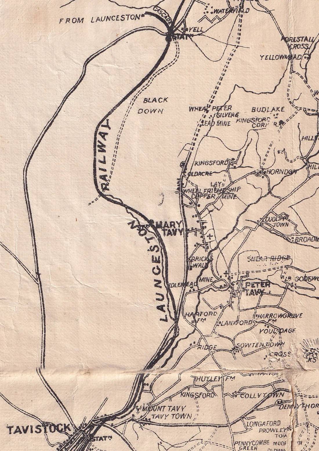
Besley also draws the railways of the day: the South Devon at Totnes and Plymouth, the Moretonhampstead and Buckfastleigh lines, the Launceston line through Tavistock, and the Devon and Cornwall line through Okehampton. The old granite tramways are on the sheet too, labelled "railway": Haytor (1820), Plymouth and Dartmoor (1823), Lee Moor (1858).
Old Dartmoor place names and Victorian spelling
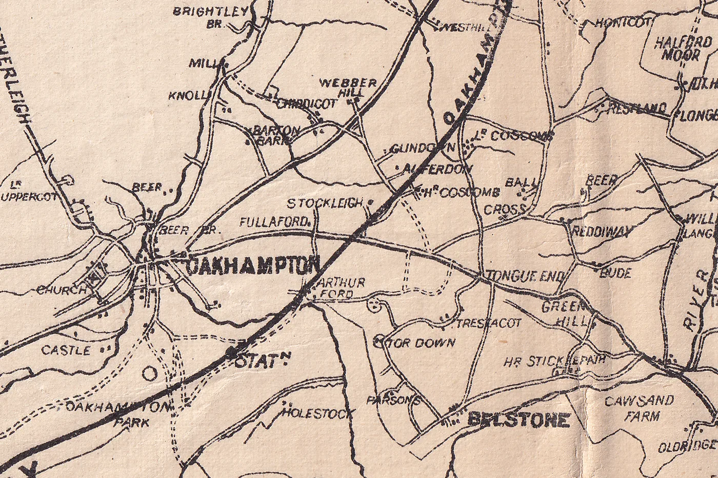
The map prints the town as OAKHAMPTON. I've seen this quite a lot during my research: White's Devonshire Directory of 1850, the Imperial Gazetteer of about 1870 and Bartholomew's Gazetteer of 1887 all give "Okehampton, or Oakhampton". Spelling was still settling, and a map printed by ear is a good place to watch it happen. Rolls Tor for Roos Tor, Braitor for Brat Tor and Widdicombe for Widecombe are all the same kind of thing.
We compared all the names with our listings on Our Dartmoor and with the full text of the old Dartmoor books I've built a database of (this is very much a work in progress and I have a massive pile of books to scan still!).
142 are spelt exactly as we spell them today. 137 are a spelling variant of something we list, and another 93 are listed under a different form.
486 match nothing we have in the listings (I'll be double checking as there are still quite a few gaps in there!).
Most of those are 486 are farms and houses, but about 55 are tors, rocks, hills and beacons, and 276 of them turn up in at least one old book, so many are real names with a paper trail and I'll have to do some proper digging around to make sure they get a place on the directory.
Old and modern Dartmoor place names compared
Each of the names below is a link: it opens the zoomable map (in a new window) I thought that the best way to see as much as possible. Spellings follow the sheet, so what looks like a mistake is often how people said the name in the 1870s. This is a list of the clear cases, not every name on the sheet.
Towns, villages and farms
| Printed on the old map | Today | A note |
|---|---|---|
| Oakhampton | Okehampton | Gazetteers of the time still gave "Okehampton, or Oakhampton" |
| Sampford Courtney | Sampford Courtenay | |
| Widdicombe In The Moor | Widecombe in the Moor | |
| Harrow Bridge | Horrabridge | |
| Wrangeton | Wrangaton | |
| Pound Gate | Poundsgate | Printed as two words |
| Post Bridge | Postbridge | Printed as two words, bridge abbreviated |
| Dennebridge | Dunnabridge | |
| Dennebridge Pound | Dunnabridge Pound | |
| Merrivelle Bridge | Merrivale Bridge | |
| Sherburton | Sherberton | |
| Hollystreet Mill | Holystreet Mill | |
| West Wick | West Week | A "wick" and a "week" are the same word, a dairy farm |
| Mid Wick | Middle Week | |
| East Wick | East Week | |
| Sowtentown | Sowtontown | |
| Souterleigh | Southerleigh | |
| Mackwood | Heckwood | The 1809 sheet has "Hackwood" |
Tors, hills and rocks
| Printed on the old map | Today | A note |
|---|---|---|
| Rolls Tor | Roos Tor | The "r" and "l" swap is the sort of thing a listener hears |
| Braitor | Brat Tor | Also Bra Tor and Brai Tor in older sources |
| Hey Tor Rocks | Haytor Rocks | Printed the same way on the 1809 Ordnance Survey sheet |
| Houndter Tor | Hound Tor | |
| Houndter Tor Down | Hound Tor Down | |
| Shellstone Tor | Shelstone Tor | |
| Lungaford Tor | Longaford Tor | |
| Baredown Tor | Bairdown Tor | |
| Scobator | Scobitor | |
| Welster | Welstor | |
| Tolman | Tolmen | The holed stone, later Tolmen |
| Cawsand Or Cawsorn Hill | Cosdon Hill | Printed with both Cawsand and Cawsorn; today Cosdon |
| Tay Cleave | Tavy Cleave | |
| Danagoal | Dunnagoat Tors | Higher and Lower Dunnagoat, above the Rattle Brook. Page (1895) offers "dun-y-coed", the wooded hill |
| Granate Tor | Gren Tor (probably) | On the sheet it sits above Woodcock Hill, where Gren Tor lies, near the head of the Lyd |
| Challer | Chat Tor (probably) | Printed where Chat Tor stands, on Rattle Brook Hill. We have found no tor called Challer |
| Omen Beam | Holming Beam | A tin working first, then peat ground. Both spellings were in use in the 1850s; see below |
| Merripit Hill | Merrypit Hill | |
| Challow Combe | Challacombe | |
| Eylesburrow | Eylesbarrow | |
| Deancomb | Deancombe | |
| Preston Berry Castle | Prestonbury Castle | Berry and bury are both "fort" |
Rivers and brooks
| Printed on the old map | Today | A note |
|---|---|---|
| Taw River | River Taw | Order of words reversed |
| Walkham River | River Walkham | |
| Yealm River | River Yealm | |
| Erme River | River Erme | |
| Avon Or Aune River | River Avon | Printed with its older name Aune as well |
| River Cowick | River Cowsic | |
| Tory Brook | Torry Brook | |
| Yealme Head | Yealm Head |
The ridge above Pew Tor (our reading, see the one-place shift below)
| Printed on the old map | Today | A note |
|---|---|---|
| Feather Tor | Barn Hill Rocks | Printed name sits on the rocks above today's Feather Tor |
| Rouge Tor | Feather Tor | The real Rouge Tor is east of Heckwood Tor, on private land |
| Sampford Tor | Heckwood Tor | Printed above Pu Tor, where Heckwood Tor lies |
| Pu Tor | Pew Tor | This one is right |
| Shop Tor | Sampford Tor (and the Shoptor farm) | Also known as Little Pu Tor |
Omen Beam: a tin working, a peat scheme and two names
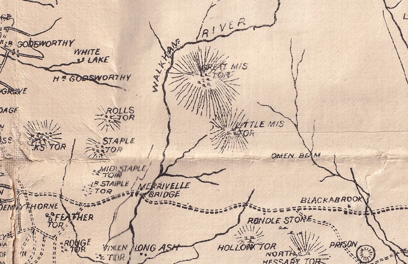
Besley prints Omen Beam beside Rolls Tor, on the whortleberry and peat ground north of the Rundle Stone. Today the Ordnance Survey calls it Holming Beam. The name is older, and odder, than the peat cutting that made it famous.
What does "beam" mean?
On Dartmoor, beam is a mining word. William Crossing's glossary in his Guide to Dartmoor says that where it is found "a deep, open working will usually be seen". His examples are Gibby's Beam, a trench running from the Wella Brook across the shoulder of Snowdon; Piper's Beam, a gully near the Avon at Huntingdon; Cater's Beam near Aune Head; and, near Princetown, "Omen Beam, or as it appears to have been formerly called, Helming Beam". In the last two cases, he adds, the name has attached itself to the hill near the workings. Other beams include Owlacombe Beam, Willabeam and Black Beam.
Crossing had already walked the ground in Amid Devonia's Alps (1888). He went "to the site of some old mining operations on Holming Beam, a tract of moor which lays between the Blackabrook and the Cowsic", and wandered over it before turning back to Great Mis Tor. So in the 1880s the name meant tin workings first and a stretch of moor second.
The word is old: Dr Tom Greeves has recorded about 150 Dartmoor beamworks, and some of the documents are much older than any peat scheme. Where the word itself comes from is not settled. R. Hansford Worth suggested, tentatively, the rocking beam of a mine pump, naming Cater's Beam and Omen Beam. Eric Hemery replied that the place-name element is older than pumping machinery, and Worth's idea has not been adopted.
The peat scheme of the 1840s
The peat story is real, but it came later. Crossing, in A Hundred Years on Dartmoor, tells it plainly: Mr Peter Adams of Plymouth, with Mr Jacob Hall Drew, began making naphtha, first at Bachelors' Hall and then in the empty war prison at Princetown. A railroad was cut from the prison to "parts of the Moor known as Omen Beam and Greena Ball", where a tract had been taken from the Duchy for its peat. At the works the peat gave naphtha, oils, candles and gas for lighting. The cost, railroad included, was £19,000, and "the enterprise did not meet with the success expected". Dartmoor: A New Study (1977) dates it to 1844 and puts the end down to the rise of coal gas.
Eric Hemery, who walked the line for Walking the Dartmoor Railroads (1983), gives the fullest account and corrects some of it. In 1844 Jacob Hall-Drew and Peter Adams, "Plymouth adventurers", rented the old mill at Bachelor's Hall for a naphtha factory, and the peat came from Yearlick Ball (the Ordnance Survey's Greena Ball) by packhorse. In 1846 their British Patent Naphtha Company rented the war prison, built a gas plant there and laid a horse tramroad to Yearlick Ball, with a branch to Omen Beam near Fice's Well. He gives the gauge as probably 4 ft 6 in, with iron trucks to stand up to the acid peat and the weather, and says it ran only as far as the prison gasworks, "not to rear of Devil's Elbow Inn, as I have seen claimed elsewhere". The prison was lit with naphtha gas from the peat, and a Crossley gas engine installed there early in the twentieth century ran on naphtha.
Hemery's walk makes Omen Beam a hill: the east side of the Blacka Brook valley north of the Rundle Stone road, with Long Plantation along its crest and "a mesh-like blanket of peat ties" over the hillside. He believes the Omen Beam branch crossed the brook on a clapper bridge and the Black Dunghill Stream on another, running east to the peat ties on the hill, though he says plainly that he found no trace of metal track there, and that ploughing for the conifers has wiped out whatever marked the end of the line. At the other end, on the Yearlick Ball line, he found a single 15 ft length of iron rail still in place, and he thinks the track was lifted during the First World War. Dartmoor Explorations also follows the Omen Beam Tramway on the ground.
It would be easy to read "beam" as a peat cutting because of all this. The tin meaning is far better supported, and it came first. Peat was also cut here for ordinary fuel: the Geological Survey memoir of 1912 lists Omen Beam among the places where peat was dug for domestic use.
The ground was berry country too. Crossing writes that Miss Sophie Dixon, who lived at Princetown, once counted more than five hundred whortleberry gatherers on Omen Beam at one time.
Omen Beam Farm and the berry pickers
Hemery's other book, High Dartmoor, adds a piece nobody else mentions: a farm. He describes the ridge of Holming Beam, "known on the Moor as 'Omen Beam'", running from the Rundle Stone road up to Black Dunghill and easy to spot from the rim of the Central Basin because of its long plantation, planted in the early twentieth century as a windbreak for the prison fields. Between the Beam and Black Dunghill lies a miry hollow, and above the left bank of its stream once stood Omen Beam Farm, fed by a pot-water leat that can still be traced. On 10 February 1808 the Duchy leased it to "William Bough of Church Row Limehouse in the County of Middlesex Civil Engineer", the land bounded east and west by "Whoming Beam Path", the track along the ridge crest, and by the Blacka Brook. John Wills seems to have been the last tenant. The farm is on the Lydford tithe map of 1840 with five enclosures and a path west to Fice's Well clapper bridge, but the growth of the convict farm after 1850 swept it away, and the plantation took the last of it. Some old enclosure walls survive on the west flank of the hill.
Hemery also records the whortleberry harvest. The Beam was once a rich gathering ground, and the berries were sold in Plymouth. He quotes F. W. Hodge, who picked "whorts" there as a boy into a cocoa tin, which he kept emptying into a large basket, and was paid a sixpenny piece for patient work.
Omen or Holming?
Two old writers disagreed about the spelling, and the mine records use both. Crossing says he took "Omen Beam" from the Ordnance map, while Moore's History of Devonshire, in a list of mines sent by John Taylor to the Lysons brothers, has "Holming Beam", as does Miss Dixon. In the Dartmoor tin survey the mine is listed under Holming Beam, with the other names Wheal Mist Tor and Omen Beam. The dates reported for it are:
| Date | Name or event |
|---|---|
| Early 1600s | Possibly "Mystlakehedd", also "Mystlake-beme" (this match is not proven) |
| 1808 | Duchy lease of Omen Beam Farm, as read by Hemery, names "Whoming Beam Path" |
| 1836 | Working recorded as "Wheal Mist Torr" |
| 1854 | Mining licence naming "Omen Beam Mine" |
| 1857 | Miners seeking a grant refer to "Holming Beam Mine Sett" |
Hemery says the moor people call the hill Omen Beam and the Ordnance Survey prints Holming, which is the reverse of what Crossing found on the map of his day. Only three years separate the last two table entries. That suggests the two names were in use side by side, not that one replaced the other. We earlier guessed that "Omen" was "Holming" with its front worn off. It may be, but nobody has found the earliest spellings that would show it, so treat it as a guess. "Holming" could be a personal name, an old local word or an altered spelling, and the English element holm, land beside water, is a possibility with no evidence behind it yet. The modern English word "omen" is almost certainly a coincidence. Nobody should read an omen into it, but they probably will - because that's a much more interesting reading (I already feel a short story coming on).
Is Holming Beam on the right spot?
A December 2024 article by Dartmoor Explorations, drawing on Dr Greeves's work, argues that Holming Beam and Holming Beam Bottom sit in the wrong place on modern Ordnance Survey maps. It puts the original workings between the Blackbrook River and the Black Dunghill Stream, in two lines of open workings about 500 and 250 metres long. That is one published reading, not a correction anyone has checked on the ground. It is not far-fetched. Hemery's Omen Beam is the hill east of the Blacka Brook, which fits it, whereas Crossing in 1888 puts the old workings on Holming Beam "between the Blackabrook and the Cowsic", which is on the other side of the brook. Crossing complained a century ago that the Ordnance map placed Cater's Beam "more than a mile too far to the west". On Besley's sheet you can search for Omen Beam in the viewer above and see where the 1870s mapmaker put it.
Still open: what would help
- Where exactly were the old tin workings, and are the names Holming Beam and Holming Beam Bottom in the right place on modern maps?
- What is the earliest dated spelling of Omen, Holming and Whoming? Does a Duchy lease, a mining licence or an estate map show an earlier one?
- Does anyone hold the 1854 and 1857 mining records, or Dr Greeves's note in the Dartmoor Tinworking Research Group newsletter?
- Where did "beam" come from in the first place? Is there a medieval or dialect source that explains it?
- Has anyone a family memory of Omen Beam Farm, or of picking whorts on the Beam?
Sources: William Crossing, Amid Devonia's Alps (1888), A Hundred Years on Dartmoor (1901), Guide to Dartmoor (glossary entry "Beam") and Crossing's Dartmoor Worker; Reid and others, The Geology of Dartmoor (1912); Dartmoor: A New Study (1977); R. Hansford Worth, On Dartmoor Place-Names, Transactions of the Devonshire Association; Tom Greeves, The Archaeological Potential of the Devon Tin Industry (1981); Eric Hemery, Walking the Dartmoor Railroads (1983), "Omen Beam Tramroad", pp. 39 to 46, and High Dartmoor, pp. 375 to 376; Legendary Dartmoor on beams and gerts.
Lost tors: Rouge Tor, Shop Tor and the ridge above Pew Tor
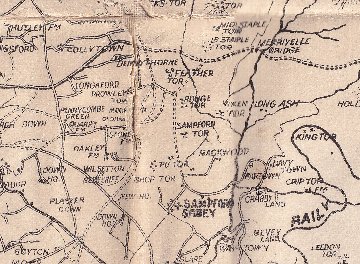
Some names match no listing and no gazetteer we hold. The best puzzle is the ridge above Pew Tor, where Besley prints Feather Tor, Rouge Tor, Sampford Tor, Pu Tor and Shop Tor.
Rouge Tor: copied, not invented
Two old guides use the name: Cresswell (1903), walking the ridge from Vixen Tor, "crossing Rouge Tor and Feather Tor", and Lloyd Warden Page, in his Exploration of Dartmoor (4th edition, 1895). No Ordnance Survey 25-inch, six-inch or one-inch map prints it. The 1809 Ordnance Survey drawing does, and so it prints Shop Tor and Hey Tor Rocks, and it spells the nearby wood Hackwood where Besley has Mackwood. It even draws Sampford Tor above Pu Tor, the slip that Besley repeats. So Besley appears to have copied the 1809 sheet, and these odd names are probably inherited, not his mishearings.
So where is Rouge Tor? Max Piper, who knows the ground, gives SX 54110 73860. That is about 380 metres east of Heckwood Tor, and on the 1840s tithe map it falls inside Whitchurch plot 738, "Outer Heckwood". The rocks are on private land. The Tors of Dartmoor site gives the same reference and describes a small, overgrown outcrop in private enclosures on a rounded hill south-west of Vixen Tor. Dartefacts also lists Rouge Tor, among its "Tors and Rocks not on OS", and also marks it as private land.
Tim Jenkinson wrote about it in "Investigating the Lost Tors of Dartmoor" (Dartmoor Magazine no. 53, Winter 1998, pages 30 to 31). He took Page's book of 1895 as the earliest mention he had found, and found a small overgrown outcrop in private enclosures south of Vixen Tor, at SX 542 738, with a field of big mossy boulders running east towards the oaks above the Walkham, and wondered if this was the missing tor. That is within about a hundred metres of Max's reference. The Besley map and the 1809 sheet show the name is older than his earliest find. His "Lesser Known Tors of Dartmoor, Part 4" (Dartmoor Magazine no. 45, Winter 1996, pages 26 to 28) puts Sampford Tor about 400 yards south of Pew Tor, at SX 531 732, and notes that Hemery calls it Little Pu Tor.
A one-place shift down the line
One explanation put to us, and it is only that, is that the 1809 surveyor asked local people for the names of the rock piles along this ridge and wrote down what he was told, and the names were then laid against the wrong piles. Reading the names from north to south, each one seems to sit a slot too far along:
| Printed on the old maps | Where we would put it today | Grid reference |
|---|---|---|
| Feather Tor | Barn Hill Rocks, the rocks above Feather Tor | SX 53457 74654 |
| Rouge Tor | Feather Tor | SX 5349 7416 |
| Sampford Tor | Heckwood Tor | SX 5376 7382 |
| Pu Tor | Pew Tor (this one is right) | SX 5324 7345 |
| Shop Tor | Sampford Tor, also known as Little Pu Tor, or the Shoptor farm below it | SX 5318 7315 |
| (no printed name found) | The real Rouge Tor, east of Heckwood Tor, on private land | SX 54110 73860 |
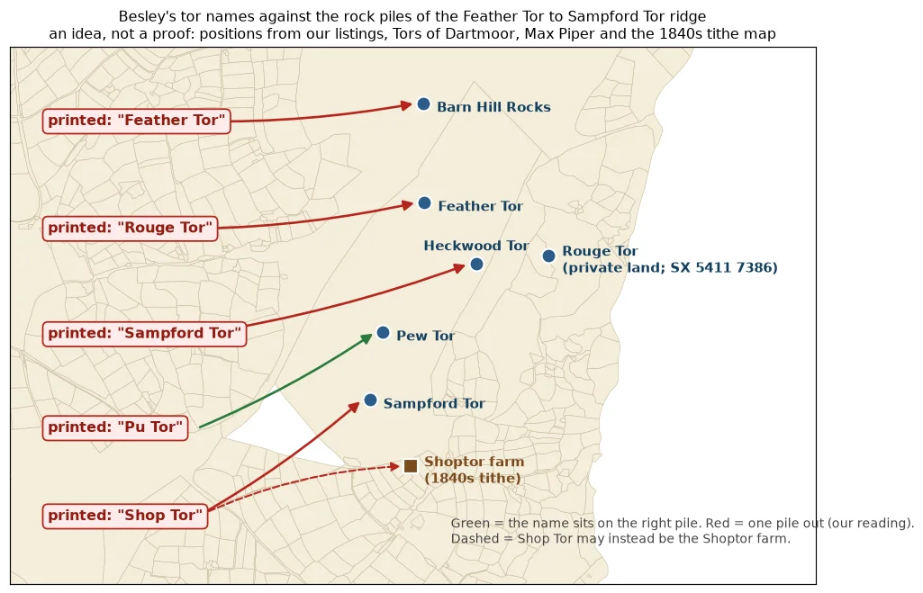
It is an idea, not a proof, and a tidy pattern like this deserves suspicion. If a local name for each pile was recorded anywhere, we would like to see it.
Shop Tor was a farm
Shop Tor is not a tor at all. The Sampford Spiney tithe apportionment of the 1840s lists a holding called Shoptor: a farmhouse with its courtlage and garden, and eight fields. The owner was Christopher Tolcher and the occupier Mary Jeffery. Matched to the tithe map, the house stands about 700 metres south of Pew Tor, on the edge of Sampford Spiney village, which is just where Besley prints "Shop Tor": below Pu Tor and just north-west of the village church. The 1809 surveyor, and Besley after him, seem to have taken a farm name for a tor.
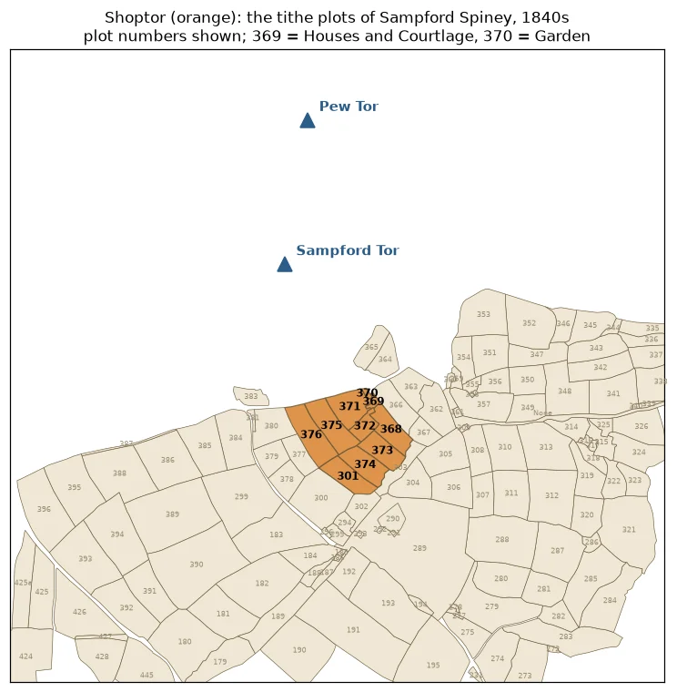
This is a 1840s record, about thirty years after the 1809 sheet, so it shows the name was in use rather than proving the 1809 surveyor meant this very farm. We have not found Shoptor in any book we hold. Does it survive today under that name?
Every place name on Besley's map of Dartmoor, A to Z
Every place name we have read off the Besley sheet, spelt as printed, in alphabetical order. Each opens the zoomable map at that spot. Where we know today's name, it is given in brackets. The names were read by computer, so a few may be misread; tell us if you spot one.
Show all 914 names
A
Abbots Row | Addyslade | Alferdon | Allen Farm | Alletshill | Amicombe | Appledore | Arms Tor | Arscot | Arthur Ford | Ash | Ashburton | Aune Head | Avon or Aune River (now River Avon) | Awsell Rock
B
Baccamoor | Baccamoor Pits | Bachelors Hall | Bak. Brook | Ball | Ballerford | Baredown | Baredown Hill | Baredown Tor (now Bairdown Tor) | Barkham | Barn | Barn Cross | Barracks | Barrow Cot | Barton Barn | Baveney | Bearah | Beardon | Bearer | Becky Fall | Beechwood | Beeland | Beer | Beer Bridge | Beetor | Beetor Cross | Bell Tor | Bellair | Belland | Bellever Farm | Bellever Tor | Belstone | Belstone Corner | Belstone Tor | Benjay Tor | Berry Castle | Bevey Land | Bickington | Bickleigh | Bickley Statn | Bittleford | Black Aller | Black Down | Black Pool | Black Tor | Blackabrook | Blackaton | Blacket | Blackland | Blackslade | Blatchford | Blatchford Viaduct | Bog Tor | Boringdon | Boringdon Park | Boringdon Wood | Bottlehill | Bovey Tracey | Bow Station | Bowden | Bowderfoldcombe | Bowdley | Bowerman's Nose | Bowerton | Boyton Moor | Bradmere Pool | Brady Moor | Braitor (now Brat Tor) | Bramblestones | Branch | Brandscombs Loaf | Brazen Tor | Brent Bridge | Brentford | Brick Wall | Bridestow | Bridon | Brightley Bridge | Brim Park | Brimmage | Briscay | Brixton Farm | Broad Barrow | Broad Down | Broadall Head | Broadmoor | Broadway | Brook | Brook Farm | Brook Hill | Brooks Farm | Brown Heath | Brunhill | Buckfastleigh | Buckland Beacon | Buckland Down | Buckland Ford | Buckland in the Moor | Buckshon Abbey | Bucton | Bude | Budgall | Budlake | Buldsbroom | Bull Brook | Bunt Hill | Burzely | Buthornstone | Buttern Hill | Butterton Hill
C
Cann Quarry | Cascade | Castle | Castor Rock Longstone | Cataract | Caters Beam | Cawsand Farm | Cawsand or Cawsorn Hill (now Cosdon Hill) | Chagford | Challer (now Chat Tor (probably)) | Challermoor | Challicot | Challow Combe (now Challacombe) | Chapel | Cheriton Bishop | Cherry Brook | Chewley | Chiddicot | Chittleford | Chitwell Rock | Cholwich Town | Christo | Church | Clanaboro | Clat | Clay | Clifford Bridge | Cocks Hill | Cocks Tor | Colebrook | Collard | Collard Tor | Colliford | Colloven | Collytown | Combe | Combe Park | Combshead | Copper Mine | Corndown | Corndown Ball | Cornwall | Cornwood | Cot | Cottage | Covatan | Crabby Cross | Crabby Land | Crabeer Pound | Crain Down | Cramber Tor | Cranbrook Castle | Cranmere Pool | Creadon | Criptor Farm | Crockern Tor | Crockernwell | Cromlech | Cross | Crossenwell Pool | Crown Hill Down | Cudlipp Town | Cumston | Cumston Tor | Cut Hill | Cuttleford | Cyclopean Bridge
D
Dalamoor | Danagoal (now Dunnagoat Tors) | Dart | Dart Bridge | Dart Head | Dartmeet Bridge | Davy Town | Dean Church | Dean Combe | Dean Court | Dean Finch | Deancomb (now Deancombe) | Deany Wood | Dennebridge (now Dunnabridge) | Dennebridge Pound (now Dunnabridge Pound) | Dennythorne | Devil's Tor | Devon | Devonport | Didsworthy | Dinger Tor | Discomd | Ditsham | Ditsworthy Warren | Dock Leat | Dockwell | Dockwell Hole | Doe Tor | Down | Down Ho. | Down Tor | Drayston | Drew Steignton | Drewston | Druid | Drylake | Drywell | Dundle | Dundridge | Dunstone
E
E.shallowford | East | East Dart | East Down | East Down Farm | East Down Hill | East Down Tor | East Miltor | East Okement River | East Rock | East Steart | East Wick (now East Week) | Eastern Overbrent | Eastern Whitborough | Eastern Whiteborough | Easton | Egg Buckland | Elfordleigh | Elfordtown | Ellycombe | Elm | Elmdon | Endsworthy | Endsworthy Hill | Erme Head | Erme Pound | Erme River (now River Erme) | Eylesburrow (now Eylesbarrow)
F
Fardle | Fardon | Farsdon | Feather Tor (now Barn Hill Rocks) | Fernworthy | Fernworthy Down | Fieldfair | Fingle Bridge | Fire Stone | Five Witches | Ford | Foresland Ledge | Forestall Cross | Fox Tor | Fox Tor Mire | Foxworthy | Fullaford | Fur Tor | Furzehill
G
Gags | Gallant Bower | Gib Hill | Gidleigh | Gidleigh Park | Ginford | Gister Down | Glaze Meet | Glundown | Gnat Tor | Gnatham | Gnattor Farm | Goodameavy | Goodamoor | Grafton | Granate Tor (now Gren Tor (probably)) | Grange Factory | Grantor | Graybarrow Pool | Great Aish | Great Halford | Great Kneeset | Great Links Tor | Great Mis Tor | Great Noddon | Great Tor | Green Hill | Grimspound | Grunnings
H
Hale | Hale Farm | Hale Mill | Halford Moor | Hall | Hall Pleasure Ho. | Halwell | Hamilton | Hamilton Beacon | Hamilton Down | Hamilton Tor | Hancely | Hanger | Hangershell Rock | Harberton | Harbour | Haretor | Harford Farm | Harrow Bridge (now Horrabridge) | Harrowbeer | Harrowgrove Farm | Harter Tor | Hartland Tor | Hayne | Hayne River | Heaborough | Head of Tory Brook | Heath Farm | Hembury | Hembury Castle | Hemerdon | Hemerdon Ball | Hennesbury | Hentor Tor | Hexworthy | Hey Tor Rocks (now Haytor Rocks) | Heytree Down | Heytree Farm | High Willhayes | Higher Bowden | Higher Cator | Higher Combe | Higher Coscomb | Higher Ditsham | Higher Downton | Higher Ford | Higher Godsworthy | Higher Grenofen | Higher Grimson | Higher Harter Tor | Higher Lee | Higher Lucans | Higher Merripit | Higher Notsworthy | Higher Sticklepath | Higher Tor | Higher Town | Higher White Tor | Higher Yeo | Hill | Hill Bridge | Hilltown | Hockner Farm | Hockner Tor | Hole | Holestock | Hollow Tor | Hollystreet Mill (now Holystreet Mill) | Holne | Holne Bridge | Holne Chase | Holne Hill | Holne Lee | Holne Ridge | Holwell | Homeavy | Honey Bag Tor | Honticot | Hook Lake | Horndon | Horridge | Horsehill Hill | Hoten | Hound Tor | Houndall | Hounder Farm | Houndter Tor (now Hound Tor) | Houndter Tor Down (now Hound Tor Down) | Howlecombe | Huntingdon Cross | Huntingdon Warren | Husson | Hutley Farm
I
Idlecot | Idlemead | Ilsington | Inner Combshead | Isever | Ivy Bridge
J
K
Keyham | King Tor | Kings Oven | Kings Wood | Kingset | Kingsford | Kingsford Corner | Knalty Barrow | Knoll
L
Lade Hill | Lag | Lake | Lakemoor | Lamb Hall | Lane End | Langcomb Head | Langdon | Langhill | Langland | Langstone | Lankford | Lay | Leather Tor | Lee | Lee Ford | Lee Moor | Lee Moor Porcelain Clay Works | Lee Town | Leedon Tor | Left Lake | Leigh Farm | Leigh Tor | Leighn | Leighn Tor | Letford Bridge | Lidford Tor | Lil Halford | Limekiln | Linch Hill | Lints Tor | Lit. Greenslade | Little Kneeset | Little Links Tor | Little Mis Tor | Littorally Tor | Lizwell | Lodge | Logan Stone | London Pit | Long Ash | Longaford | Longbeer | Longoetor | Longstone | Longstone Hill | Lough Tor | Loughron Tor | Loughton | Lower Bearah | Lower Bowden | Lower Cator | Lower Combe | Lower Coscomb | Lower Ditsham | Lower Downton | Lower Ginford | Lower Godsworthy | Lower Grenofen | Lower Grimson | Lower Harter Tor | Lower Lee | Lower Lucan | Lower Morchington | Lower Notsworthy | Lower Staple Tor | Lower Uppercot | Lower White Tor | Lower Yeo | Lowry | Lucksmoor | Lukesland | Lungaford Tor (now Longaford Tor) | Lustleigh | Lustleigh Cleeve | Lutton | Lydford
M
Mackwood (now Heckwood) | Madford | Makeham | Malhanger Farm | Manaton | Marley House | Marsh Mill Stat'n | Marshallscombe | Mary Tavy | Maunton Tor | Meadowrby | Meavy | Memil | Merripit | Merripit Hill (now Merrypit Hill) | Merrivelle Bridge (now Merrivale Bridge) | Merryfield | Merrymeet | Mid Lucan | Mid Rock | Mid Staple Tor | Mid Wick (now Middle Week) | Middle Brook | Middlecot | Middlemoor | Middleton Hill | Middleworth | Midl Staple Tor | Mill | Mill Tor | Mine | Monks Hill | Moor Gate | Moorgate Toll Gate | Moorshead | Moortown | Moreton Hampstead | Moreton Woods | Mount Tavy
N
Nackwood | Narrow Moor | Narrow Tor | Nats Farm | Neighdon | Nelghdon | Nether Shaugh | New Bridge | New Ho. | New House | New Mill | Newcombe | Newlake | Newnham Park | Nillcomb | North Bovey | North Harton | North Hessary Tor | North Stock | North Tawton Station | North Teign | North Week | Northway | Northwood | Nosworthy | Noten | Nuns Cross | Nurston
O
Oakhampton (now Okehampton) | Oakhampton Park | Oakley Farm | Okement Hill | Oldacre | Oldham | Oldridge | Omen Beam (now Holming Beam) | Owlicombe | Oxenham
P
Pain Bridge | Paper Mill | Park | Parsonage | Parsons | Partown | Pear Tree | Peat Cot | Peck | Peck Hill | Peckets Ford | Pen Beacon | Penaton | Pennaton | Pennycombe Green | Peter Tavy | Peters Bound Stone | Peters Cross | Pethill | Pillens | Pin Park | Pincherford | Pithill | Pitmans | Place Ho. | Plaster Down | Plym Head | Plym Steps | Plymouth | Plymouth and Dartmoor Raily | Plympton St Mary | Polstone | Pondsworthy | Porcelain Clay Works | Post Bridge | Pound Gate (now Poundsgate) | Prescomb | Preston | Preston Berry Castle (now Prestonbury Castle) | Prewley | Prewley Down | Pridhamsleigh | Prince Hall | Prince Town | Prison | Prowley Town | Prushwell | Pu Tor (now Pew Tor) | Pulsow | Puppers
Q
Quantan Rock | Quarry Farm | Quckwell | Quickbeam Hill or Erme Plains
R
Race Wo. | Raleigh | Rashley | Rattery | Rattle Brook | Red Lake | Red Stone | Redbrook Ball | Redcriff | Reddiford Down | Reddiway | Reddy Clay | Redford | Renden | Restland | Rew | Riddy Hill | Ridge | Ringmoor Down | Rings | Rippon Tor | Rithy Pit | Rival Tor | River | River Cowick (now River Cowsic) | River Dart | River Lyd | River Plym | River Taw | Roborough Down | Rock Tor | Rocks Inn | Rolls Tor (now Roos Tor) | Rondle Stone | Roslade | Rouge Tor (now Feather Tor) | Row Tor | Rowbrook | Rray Barton | Rummage | Rushford B. | Rushford Mill | Ryders Hill | Ryders Plain
S
Saddle Tor | Saddleborough | Samford | Sampford | Sampford Courtney (now Sampford Courtenay) | Sampford Moors | Sampford Spiney | Sampford Tor (now Heckwood Tor) | Sampson | Sanddown | Scarey Tor | Scobator (now Scobitor) | Scorhill Tor | Scoriton | Shagh Bridge | Shaldon Barrow | Shapeley Common | Sharp Tor | Shaugh Prior | Shaugh Wood | Shavercomb Head | Sheepley | Sheepstor | Sheepstor Bridge | Shell Tor | Shellstone Ash | Shellstone Tor (now Shelstone Tor) | Sherburton (now Sherberton) | Sherrels | Sherwell | Shipley Bridge | Shipley Tor | Shop Tor (now Sampford Tor (and the Shoptor farm)) | Shute | Shuttle Ford | Sidstone | Silver Hill | Skeriton | Skin | Skinnings | Slade | Slade Mill | Slade Viaduct | Slare Town | Slinwill | Slippaddon | Small Hanger | Smear Ridge | Smith Hill | Smithy | Snapper Tor | Sortridge | Sourton | Sourton Tor | Souterleigh (now Southerleigh) | South Brent | South Combe | South Cot | South Dornaford | South Down | South Harton Way Farm | South Shute Common | South Tawton | South Teign | South Zeal | Southway | Sowtentown (now Sowtontown) | Sparkwell | Spitchwick | Stamping Ho | Stancomb | Stand Barn | Stanton Hill | Staple Tor | Statcombe Wood | Station | Stean Lake | Steeperton Tor | Stentaford | Stewards Mill | Sth Stone Farm | Sth. Devon Ry. | Stock | Stockleigh | Stoke | Stonan Farm | Stone | Stone Farm | Stony Bottom | Studeley | Suldaford Tor | Summer Bridge | Summer Hill | Summer Ho | Sunhill | Swincombe
T
Taddebrook | Tar Mill | Tarr | Tavistock | Tavy Town | Taw Green | Taw Head | Taw Moor Ho. | Taw River (now River Taw) | Tay Cleave (now Tavy Cleave) | Teign | Tenevor | Ternhill | Thatchels | The Compass Points | The Rings | Thorn | Thornworthy Tor | Three Barrows | Throwleigh | Tolman (now Tolmen) | Tongue End | Tor | Tor Dean | Tor Down | Tor Rocks | Tor Royal | Tor Royal Ho. | Tory Brook (now Torry Brook) | Totnes | Town | Tresacot | Tristis Rock | Trowlesworthy | Trowlesworthy Tor | Trunnings | Tunhill | Two Bridges
U
Ugborough Beacon | Unsure Which Text or Drawing You Are Referring To | Unterton | Uppercot | Upperton
V
Venn Hill | Ventor | Vicarage | Vinter Tor Mine | Vixen Tor
W
W.combe Farm | W.shallowford | Wadley Brook | Walbrook Bridge | Walkham | Walkham River (now River Walkham) | Walkhampton | Walla Brook | Wallford | Wallow | Wallow Brook | Wanston | Warden | Warnicombe | Warren Tor | Waspworthy | Water Farm | Water Rock | Waterfield | Waterleat | Waterleat Moor | Watern Oak | Watern Tor | Wattiford Down | Way | Way Farm | Way Town | Weald | Weare | Webber | Webber Hill | Week Green | Welltown | Welster (now Welstor) | West Cott | West Dart | West Mil Tor | West Okement River | West Rock | West Steart | West Wick (now West Week) | Western Beacon | Western Overbrent | Western Whiteborough or Peters Cross | Westhill | Wheal Franco Mine | Wheal Friendship Copper Mine | Wheal Peter Silver & Lead Mine | Whiddon Park | Whitberry | Whitchurch | Whitchurch Down | White Axen | White Hill | White Lake | White Works | Whitecot | Wickey Farm | Wickington | Widdicombe in the Moor (now Widecombe in the Moor) | Wigford Down | Wild Tor | Willey | Willowrby | Wilsetton | Wilsworthy | Wingreen | Wisdom | Wistman's Wood | Wolkismore | Woller | Wollon | Wood | Wood Ball | Wood End | Woodcock Hill | Woodford | Woolford Bridge | Wooston Castle | Wormhill | Wormslake | Wrangeton (now Wrangaton) | Wreke
Y
Yadsworthy | Yandiston Down | Yar Tor | Yard | Yarnour Wood | Yealm River (now River Yealm) | Yealme Head (now Yealm Head) | Yell | Yellowmead | Yene | Yenny Lake | Yentown | Yeoford Junction | Yes Tor | Yolland | Youldage | Youldon
Look closely and tell me what you find
This article is a work in progress, and I would rather get it right with your help than guess. If you know any of the following, or have a better idea, please tell me on the contact page:
- Has anyone seen a dated copy of this sheet, or another Besley Dartmoor map?
- Does the Shoptor farmhouse still stand, and is the name still used?
- Which of the names have I misread? I read them by computer and by eye, so some are bound to be wrong.
- Where were the old Holming Beam workings, and what does "beam" mean (see the Omen Beam section)?
- Can you place any of the "probably" names in the table, such as Challer and Granate Tor, or the unexplained dotted railway lines near Lydford?
- Do you research Dartmoor place-names, mining or old maps, and fancy comparing notes?
I will keep adding to this as I scan more maps and books.
Frequently asked questions
Who made the Besley map of Dartmoor?
When was Besley's map of Dartmoor made?
Why does the map spell Okehampton as Oakhampton?
Can I search the names on the Besley map?
Where is Rouge Tor?
Was Shop Tor a tor?
What is Our Dartmoor?
What else can I find on Our Dartmoor?
How can I contribute to Our Dartmoor?
Further reading
- Tourist Maps of Devon, Henry Besley and the entries on Besley 8 and Besley 9.
- Printed Maps of Exeter, Henry Besley.
- Victorian Maps of Devon, map 134.
- White's Devonshire Directory (1850), via GENUKI.
- Tors of Dartmoor: pages on Rouge Tor, Heckwood Tor, Sampford Tor, Pew Tor and Feather Tor.
- Tim Jenkinson, "Investigating the Lost Tors of Dartmoor", Dartmoor Magazine no. 53, Winter 1998, pages 30 to 31 (Rouge Tor); and "Lesser Known Tors of Dartmoor, Part 4", Dartmoor Magazine no. 45, Winter 1996, pages 26 to 28 (Sampford Tor).
- Cresswell, Dartmoor and its Surroundings (1903); Page, An Exploration of Dartmoor and its Antiquities; Crossing, Guide to Dartmoor (1914).